Science
Advantages of Satellite Platforms for Monitoring Urban Areas

Monitoring urban areas via satellite platforms is very important, as it helps us determine if the terrain can be used for building something in the future and more. Find out how satellite platforms register atmospheric and geological data.
How Are Satellite Platforms Analyzing and Monitoring Urban Areas?
When discussing the benefits of satellite platforms for monitoring urban areas, technological requirements and the problems associated with them should be taken into consideration first. Today’s satellite platforms are all about contextual and interpretation dimensions.
Also, the covered surfaces of heterogeneity and temporal atmospheric differences no longer get noticed when registering different scenes. Urban areas’ problems should be analyzed together with the reference surfaces that should undergo atmospheric corrections.
Using targeted control points when it comes to temporal change monitoring is to be considered, too. Specific advantages that involve data from high-resolution satellites will be discussed here so that you can better understand what satellite platforms for monitoring urban areas are all about.
What’s a Satellite Platform?
A satellite platform, aka satellite bus, hosts all electronic equipment and payloads necessary for the satellites to do their job.
Synoptic images at improved and varied temporal or spatial resolution come from satellite technology with sensors and are used for the purpose of land-use and urban growth classification studies.
The data coming from satellite platforms are useful for studying time-variant processes that involve urban monitoring and expansion.
To understand how satellite platforms help with urban area monitoring, let’s take the continuous growth of migration in Saudi Arabia.
People are moving from the countryside so that they can have improved prospects and the process of industrialization increases.
This means that the business and commerce sectors will improve, not to mention that the service sector will evolve a lot, too. The best idea is to use satellite platforms for monitoring the urban scenarios timely and by using Satellite Sensing Technology.
In this manner, the changing patterns will be systematically studied, and future development will be planned accordingly by employing satellite platforms and other technologies.
Why Are Satellites Useful?

Urban monitoring utilizes multi-data high-resolution images obtained through digital and visual processing from satellite platforms.
The results of satellite platform studies provide the most timely and valuable qualitative and quantitative inputs to managers who are concerned with development and planning. There’s also a need to collaborate with metropolitan development agencies in Saudi Arabia to address the most common urban problems.
When spatiotemporal changes from large urban agglomerations are monitored, it becomes more important to study the proportion and number of urban residents, and both these continue to go higher.
For as long as the urban landcover’s synoptic view provided by airborne sensors and satellite platforms gets to be in situ in the environmental, socioeconomic, and physical settings, the urban plans will continuously change.
Most operational satellite platforms have impeded spatial resolution and how sensed imagery has helped with remotely studying the urban infrastructure.
Resolution is enough for measuring important environmental parameters that are logistically prohibitive or difficult to obtain data from these platforms. Besides, it is very expensive to measure things directly from a platform.
Moreover, intra-urban variations abundant in vegetation influence the environmental conditions and fluxes between mass and energy.
Quality of life in urban areas is selective when it comes to reflecting solar radiation and the absorption of evapotranspiration’s modulation.
Operational satellites like Landsat provide the ability to monitor solar radiation absorption and selective reflection.
Spatiotemporal dynamics in urban vegetation and monitoring the spatiotemporal dynamics of thermal emission is simultaneous when it comes to interannual and seasonal time scales, making it easier to understand their connections in the urban environment.
Spatiotemporal variations monitoring of urban vegetation is abundant and makes phenology easier to practice.
When measuring urban vegetation and comparing how the vegetation distributions are in Guangzhou and New York, the Landsat TM platform imagery sends the necessary information to scientists on Earth.
Analyzing spatiotemporal dynamics, urban areas and pollution are two intertwined factors that influence the urban areas’ quality of life.
Why Do We Need Satellite Platforms?
A satellite platform helps dock satellites and their equipment. Future research is in the planning to address the scientific issues that have been mentioned above. The avenue of intended future research is going to address the problems.
For example, the SPOT-1 pan imagery from 1987 has a 10m resolution and should have results fused with imagery from 1986. This way, higher classification can become comparable with what scientists plan to improve urban areas.
When the light-textured soil areas are deteriorating, weather practices turn in favor of slaking. Back in 1979, the polder soil slaked and got reclaimed, but the moisture content of the soil, as well as penetration resistance, increased.
And changes in soil are causing surfaces to shrink, whereas the radiant temperature gets to be ±2degree C.
Spacecraft platforms and analyzing imagery have been excessively helpful in obtaining this data. Today, more advanced satellite platforms contribute even more insight into urban environments.
Related CTN News:
Why Do People Believe That CERN’s Large Hadron Collider Could End The World Today, July 5?
Scientists Discover World’s Largest Bacterium, The Size Of An Eyelash
New Dinosaur Species Having Knives For Claws Discovered In Japan’s Hokkaido

Science
NASA Switches Off Instrument On Voyager 2 Spacecraft To Save Power
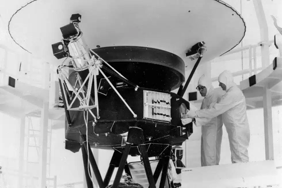
NEW YORK — To save power, NASA turned off another scientific equipment on its long-running Voyager 2 spacecraft.

NASA Switches Off Instrument On the Spacecraft To Save Power
The space agency announced on Tuesday that 2’s plasma science instrument, meant to study the movement of charged atoms, was turned off in late September to allow the spacecraft to continue exploring for as long as possible, which is estimated to be into the 2030s.
NASA turned off a suite of instruments on Voyager 2 and its twin, Voyager 1, after exploring the gas giant planets in the 1980s. Both are currently in interstellar space or the region between stars. The plasma instrument on Voyager 1 stopped working years ago and was finally shut off in 2007.
The remaining four instruments on 2 will continue to collect data on magnetic fields and particles. Its mission is to investigate the regions of space beyond the sun’s protective sphere.
NASA Switches Off Instrument On Voyager 2 Spacecraft To Save Power
It launched in 1977, is the only spacecraft to have visited Uranus and Neptune. It is now more than 12 billion miles (19.31 billion kilometers) from Earth. 1 is more than 15 billion miles (24.14 billion kilometers) beyond Earth.
SOURCE | AP
Science
Hurricane Kirk Could Cause Dangerous Surf Conditions Along The US East Coast
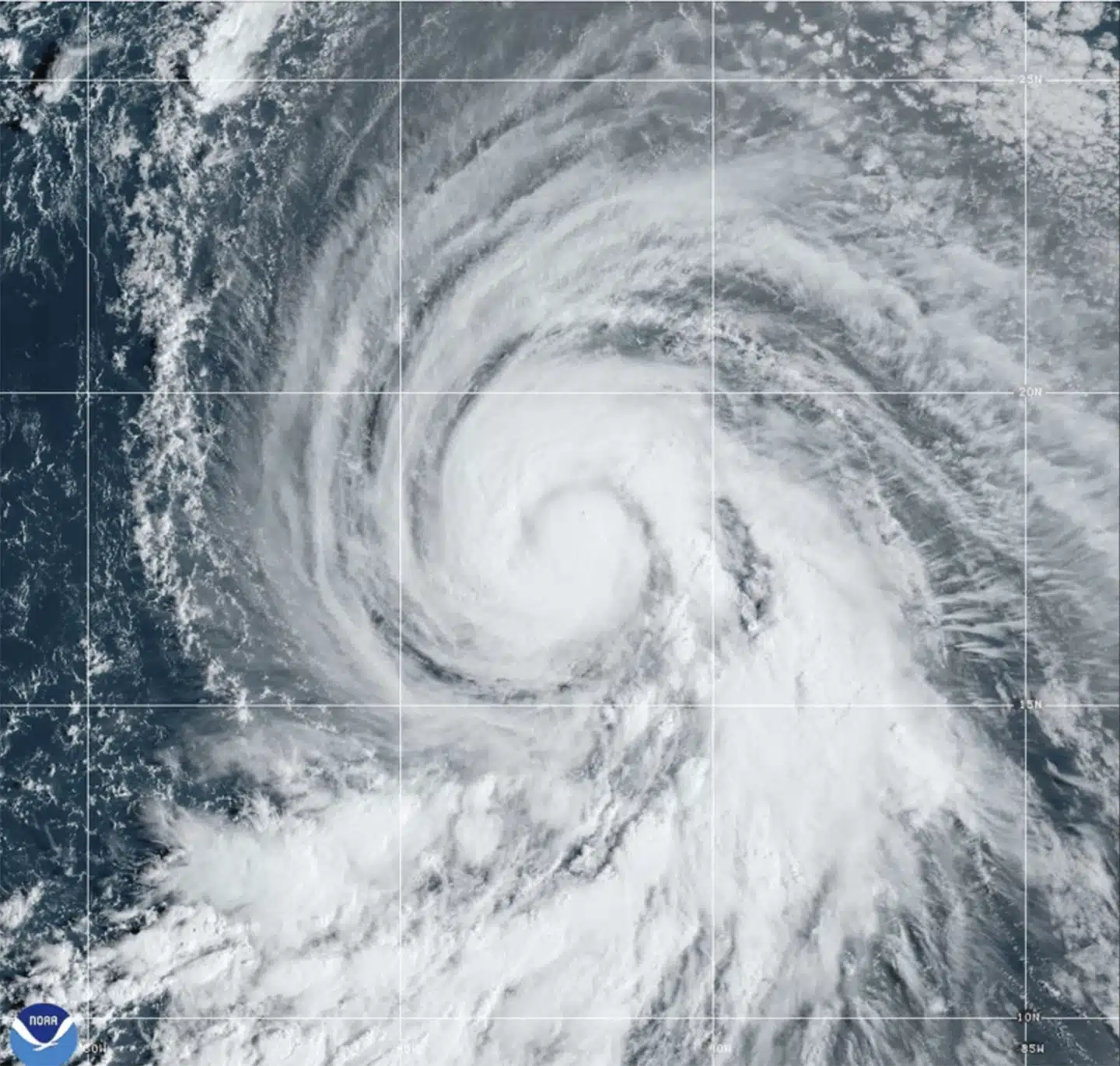
MIAMI — Hurricane Kirk’s waves could generate life-threatening surf and rip current conditions this weekend throughout the United States East Coast, as well as in Bermuda, the Greater Antilles, and the Bahamas, according to forecasters.
Kirk was a Category 3 hurricane in the middle Atlantic Ocean that might grow further but was predicted to stay away from land, according to the Miami-based National Hurricane Center on Thursday.
Hurricane Kirk Could Cause Dangerous Surf Conditions Along The US East Coast
Kirk-generated swells were forecast to reach parts of the Leeward Islands on Friday, Bermuda and the Greater Antilles on Saturday, and the East Coast and the Bahamas on Sunday, according to the center.
No coastal watches or warnings were in effect. The major storm was around 1,130 miles (1,820 kilometers) east of the Leeward Islands, with maximum sustained winds of 125 mph (205 km/h).
Meanwhile, Tropical Storm Leslie formed late Wednesday in the eastern Atlantic and is expected to strengthen into a hurricane in the following days, forecasters said. It was also not considered a threat to the land.
Hurricane Kirk Could Cause Dangerous Surf Conditions Along The US East Coast
The storm was about 540 miles (870 kilometers) southwest of Cabo Verde’s southernmost tip, with maximum sustained winds of 45 mph (75 kph), according to the center.
The storms raged in the Atlantic as rescuers in the United States Southeast sought for missing persons after Hurricane Helene struck last week, leaving a trail of death and devastation.
SOURCE | AP
Science
NASA Sends First Manned Starliner Spacecraft to Space Station
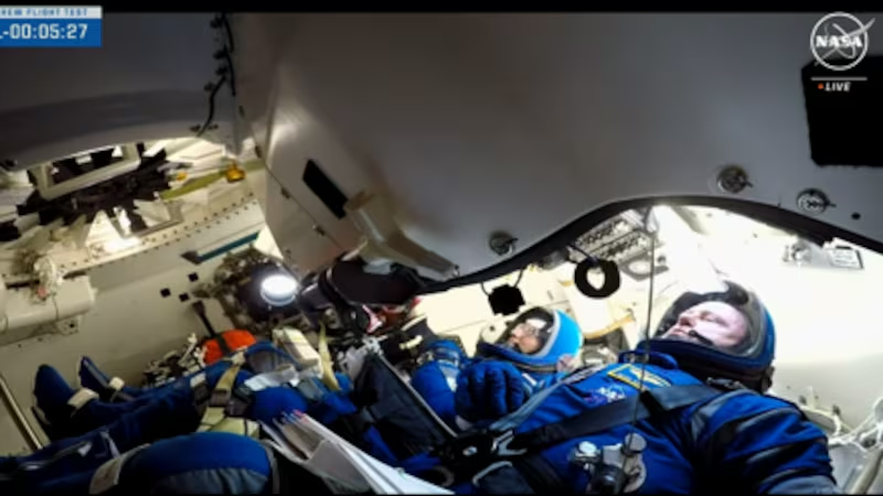
NASA has announced astronauts Butch Wilmore and Suni Williams are safely in orbit on the first crewed flight test of Boeing’s Starliner spacecraft heading for the International Space Station.
As part of NASA’s Boeing Crew Flight Test, the astronauts launched a ULA (United Launch Alliance) Atlas V rocket from Space Launch Complex-41 at Cape Canaveral Space Force Station in Florida at 10:52 a.m. EDT Wednesday for an end-to-end test of the Starliner system.
“Two brave NASA astronauts are well on their way to this historic first test flight of a brand-new spacecraft,” stated NASA Administrator Bill Nelson. “Boeing’s Starliner represents a new era of American exploration. Human spaceflight is a risky endeavor, but it is worth it. It is an exciting time for NASA, our commercial partners, and the future of space exploration. “Go Starliner, Butch, and Suni!”
The flight test is part of NASA’s Commercial Crew Program and will help validate the transportation system, launch pad, rocket, spacecraft, in-orbit operations capabilities, and return to Earth with astronauts aboard as the agency prepares to certify Starliner for rotational missions to the space station. Starliner has already completed two uncrewed orbital missions, including a test to and from the space station, as well as a pad abort demonstration.
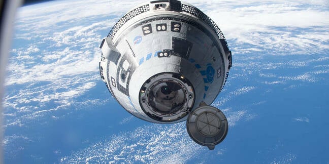
Boeing Starliner Makes Orbit
“With Starliner’s launch, separation from the rocket, and arrival in orbit, Boeing’s Crew Flight Test is right on track,” said Mark Nappi, vice president and program manager for Boeing’s Commercial Crew Program. “Everyone is focused on giving Suni and Butch a safe, comfortable, ride and performing a successful test mission from start to finish.”
Boeing’s mission control center in Houston will supervise a sequence of autonomous spacecraft maneuvers while Starliner is in flight. NASA teams will supervise space station activities from the Mission Control Center at the agency’s Johnson Space Center in Houston.
“Flying crew on Starliner represents over a decade of work by the Commercial Crew Program and our partners at Boeing and ULA,” said Steve Stich, Commercial Crew Program Manager at NASA’s Johnson Space Center in Houston. “For many of us, this is a career-defining occasion, ushering in a new crew transportation capacity for our agency and our country. We will take it one step at a time, putting Starliner through its paces and remaining watchful until Butch and Suni safely land back on Earth at the end of this test journey.”
At about 12:15 p.m., Starliner will dock autonomously to the forward-facing port of the station’s Harmony module. Thursday, June 6, and will remain at the orbital laboratory for almost a week.
Wilmore and Williams will help ensure that the spacecraft is functioning properly by testing the environmental control system, the displays and control system, and moving the thrusters, among other things, during flight.
Wilmore and Williams will join the Expedition 71 crew, which includes NASA astronauts Michael Barratt, Matt Dominick, Tracy C. Dyson, and Jeanette Epps, as well as Roscosmos cosmonauts Nikolai Chub, Alexander Grebenkin, and Oleg Kononenko.
NASA’s arrival and in-flight event coverage is as follows (all times Eastern and subject to change depending on real-time operations):
NASA Television channels will continue to broadcast the Starliner’s mission.
Thursday, June 6
9:30 a.m. – Arrival coverage begins on NASA+, the NASA app, and YouTube, and continues on NASA Television and the agency’s website.
12:15 p.m. – Targeted docking
2 p.m. – Hatch opening
2:20 p.m. – Welcome remarks
3:30 p.m. – Post-docking news conference at NASA Johnson with the following participants:
- NASA Associate Administrator Jim Free
- Steve Stich, manager, NASA’s Commercial Crew Program
- Jeff Arend, manager for systems engineering and integration, NASA’s International Space Station Office
- Mark Nappi, vice president and program manager, Commercial Crew Program, Boeing
Coverage of the post-docking news conference will air live on NASA+, NASA Television, the NASA app, YouTube, and the agency’s website.
To attend the post-docking briefing, U.S. media must contact the NASA Johnson newsroom at: jsccommu@mail.nasa.gov or 281-483-5111 by 1 p.m. Thursday, June 6. To join by phone, media must contact the NASA Johnson newsroom by 3 p.m. Thursday, June 6.
5:50 p.m. – NASA Administrator Bill Nelson, Deputy Administrator Pam Melroy, Associate Administrator Jim Free, Associate Administrator for Space Operations Ken Bowersox, and Johnson Space Center Director Vanessa Wyche will speak with Wilmore and Williams about their launch aboard the Starliner spacecraft.
Coverage of the Earth to space call will air live on NASA+, NASA Television, the NASA app, YouTube, and the agency’s website.
Saturday, June 8
8:50 a.m. – NASA astronauts Wilmore and Williams will provide a tour of Starliner.
Coverage of the in-orbit event will stream live on NASA+, NASA Television, the NASA app, YouTube, and the agency’s website.
Monday, June 10
11 a.m. – Williams will speak to students from Sunita L. Williams Elementary School in Needham, Massachusetts, in an event aboard the space station.
Coverage of the Earth to space call will air live on NASA+, NASA Television, the NASA app, YouTube, and the agency’s website.
Tuesday, June 11
3:15 p.m. – Wilmore will speak to students from Tennessee Tech University in an event aboard the space station.
Coverage of the Earth to space call will air live on NASA+, NASA Television, the NASA app, YouTube, and the agency’s website.
-

 News3 years ago
Let’s Know About Ultra High Net Worth Individual
-
Entertainment2 years ago
Mabelle Prior: The Voice of Hope, Resilience, and Diversity Inspiring Generations
-

 Health4 years ago
How Much Ivermectin Should You Take?
-

 Tech2 years ago
Top Forex Brokers of 2023: Reviews and Analysis for Successful Trading
-
 Lifestyles3 years ago
Aries Soulmate Signs
-

 Movies2 years ago
What Should I Do If Disney Plus Keeps Logging Me Out of TV?
-

 Health3 years ago
Can I Buy Ivermectin Without A Prescription in the USA?
-

 Learning3 years ago
Virtual Numbers: What Are They For?